

When "Low Density" is actually HIGH density!
Citizens needed: 2/15 at 10 am: Future Land Use Map update will PROMOTE high density development if not changed.

Did you know that the county government changed the definition of “high density” housing to be inaccurately called “low density”? Did you know that this will allow actual high density housing at six houses per acre to be developed all over Bartow county? How did this happen and how can you stop it? Read the path to this below To stop it, show up this week!
How to ensure only LOW Density housing is developed in the actual “Low density” residential areas of the future land use map.
On Wednesday, 2/15 at 10 a.m., Come to the Commissioner's Conference/Hearing Room, 135 W. Cherokee Avenue, Suite 251, Cartersville.
Sign up to speak and ask the Commissioner Steve Taylor to:
· Add text to the Future land Use Plan that <10% of the proposed residential development in the area designated “low density” would be “R-8”.
· To revise the county ordinances so that R-8 would again be designated as “medium and high density” (as it was in 10/21).
On Wednesday, 2/15 at 10 am, the County is set to approve an “update” of its ten year future land use map that guides future development in Bartow County. However there is a false definition of “low density” being built in that will allow actual HIGH DENSITY housing to be developed in Bartow County. This would be in contradiction to the actual ordinances of the County (see below) and the desires of the citizens as expressed1 in a survey as part of this land use update process.
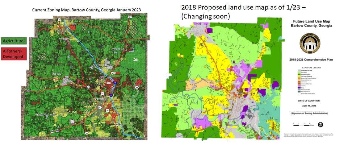
The planned land use indicates area of “low density” residential development in many areas, including all along Highway 41 up to Adairsville, West of Burnt Hickory, North and South of Highway 20 (west of I-75) and more. However the county changed their ordinances in 2021 to include R-8 as a “low density” development. R-8 is a zoning district that had been defined as “high density” for many years. That allows six houses to be built on 1 acre. This is not in keeping with the character of Bartow county or the wishes of Bartow citizens.
This also has implications for the Aubrey Corporation re-development that would designate large areas of agricultural and forest land as “low-density” residential. But, as shown here, that means “high-density” single family homes.
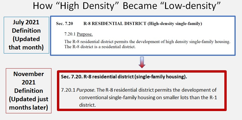
Low density definition change history
The “high-density” definition of R-8 was CONFIRMED as recently as 7/14/21. Then, after citizens successfully worked to stop an R-8 development along fire tower road in September 2021. It became clear to the county that the correct designation of “High- density” for R-8 had to go. So, with the stroke of a pen and a vote of the County Commission, it was changed to “low-density”. That is right the meaning of the word “high” was changed to “low”, to allow hyper-dense development to more easily occur in Bartow county.
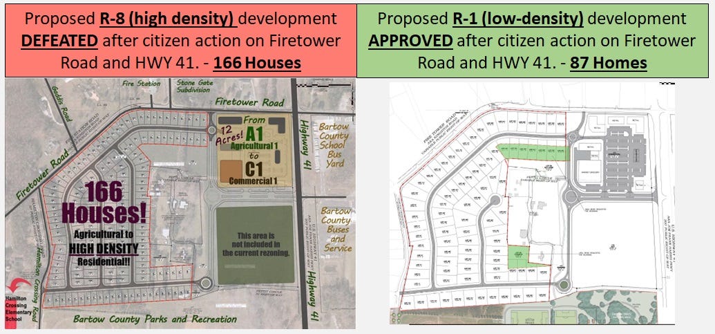
What prompted this? The Firetower Rd Development at the intersection of Highway 41 was stopped by a group of dozens of citizens. The original land owner certainly had the right to ask for the designation to be changed to A-1 to a residential designation so he could sell. However the citizens in the community objected to it being proposed as “R-8” which would have squeezed 166 homes on the site. After the battle was fought for months, in grassroots efforts directed at the zoning commission and county commissioner, the designation was changed to R-1. That means that now only 87 houses are approved to be built there. This is much more in keeping with the County ordinances which state as follows in Article II, J of zoning ordinances “purposes”:
“To protect against overcrowding of land, overcrowding of population in relation to the community facilities existing or available, obstruction of light and air, danger and congestion in travel and transportation, and loss of life, health or property from fire, flood, or other danger.”
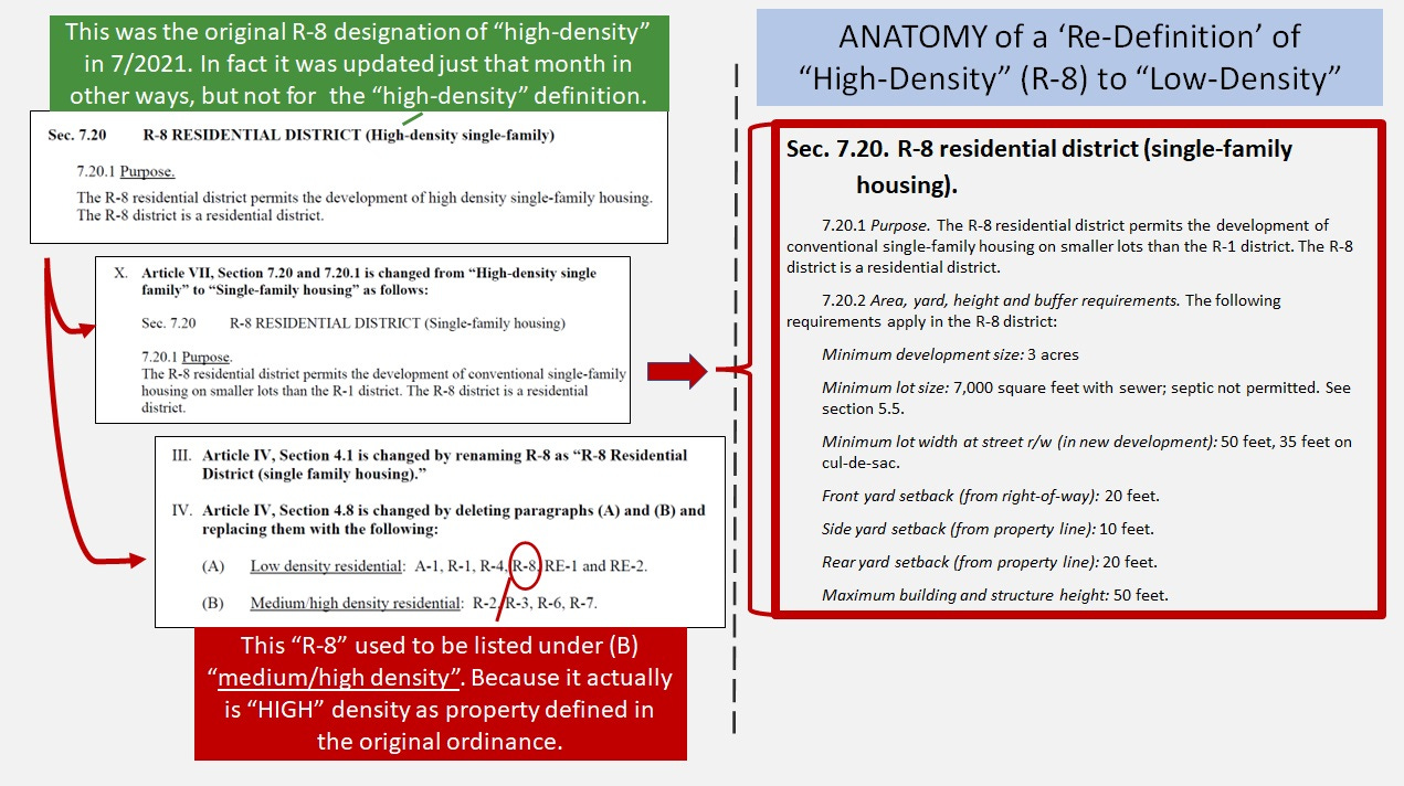
Very quickly after the citizen victory, the county staff spring into action to change the definition of “R-8” to read “low density”. Despites citizen objections to this, the change sailed through ordinance approval by the County Commission. The sequence of change is demonstrated in how the ordinances were altered after July 2021. (See “Anatomy of a “Re-definition” image above and this county staff offered justification below)2. The staff justification admitted that it was high density but not "as high" as apartments and the like. Seems like a stretch to justify such a change. It is curious that the “high density” change was not made during that update in July 2021 and did not actually occur until 11/2021 after the Firetower road victory by grassroots citizen action.
Now the future land use map states “low-density” in large swaths or yellow on the map. However, in reality, that means that actual high density housing could be built at throughout all these areas.
To repeat, the main point - ahem:
High density housing can be built throughout all the “low - density” areas in Bartow county due to a definition change by the county government.
If you want to work to keep development at low-density, please show up to ensure only LOW Density housing is developed in the actual “Low density” residential areas of the future land use map.
On Wednesday, 2/15 at 10 a.m., Come to the Commissioner's Conference/Hearing Room, 135 W. Cherokee Avenue, Suite 251, Cartersville.
Sign up to speak and ask the Commissioner Steve Taylor to
· Add text to the Future land Use Plan that <10% of the proposed residential development in the area designated “low density” would be “R-8”.
· To revise the county ordinances so that R-8 would again be designated as “medium and high density” again (as it was in 10/21).
In Freedom!
“The R-8 Zoning District was drafted and approved in 2017. It allowed single family lots at 7,000 square feet, or roughly 6 units per acre. At the time staff decided an R-8 zoning application would need to be in the Medium/High Density land use designation on the Future Land Use Map. After reviewing several R-8 zoning applications, staff has determined R-8 would be a better fit in the Low Density Residential land use designation. While R-8 is higher density single family than R-1, it is not at the same density as multi-family developments such as townhomes and apartments. Historically, those uses have been allowed in the R-3 District, which related to the Medium/High Density land use designation. Townhomes and apartment developments tend to be 12 to 15 units per acre; one apartment development under construction will be almost 40 units per acre. While 6 units per acre is higher than the R-1 District, because it is not as high density as townhomes and apartments staff believed it should not be lumped in with those uses on the Future Land Use Map.”